![](/images/other/stat-length.png)
![Tocht Te voet São Roque do Pico - Caminho das Lagoas - Photo](https://media.geolcdn.com/t/1900/400/90bf9d93-151d-4f77-932f-b7106031c39b.jpeg&format=pjpeg&maxdim=2)
Caminho das Lagoas
SityTrail - itinéraires balisés pédestres
Tous les sentiers balisés d’Europe GUIDE+
![Lengte](/images/other/stat-length.png)
Lengte
22 km
![Max. hoogte](https://static1.geolcdn.com/siteimages/upload/files/1508320355ic_sort_altitude_max_24dp.png)
Max. hoogte
975 m
![Positief hoogteverschil](https://static1.geolcdn.com/siteimages/upload/files/1508320355ic_sort_den_pos_24dp.png)
Positief hoogteverschil
374 m
![Km-Effort](/images/other/stat-length.png)
Km-Effort
28 km
![Min. hoogte](https://static1.geolcdn.com/siteimages/upload/files/1508320355ic_sort_altitude_min_24dp.png)
Min. hoogte
397 m
![Negatief hoogteverschil](https://static1.geolcdn.com/siteimages/upload/files/1508320355ic_sort_den_neg_24dp.png)
Negatief hoogteverschil
690 m
![Boucle](https://static1.geolcdn.com/siteimages/upload/files/16400158638029165_repeat_loop_refresh_sync_direction_icon.png)
Boucle
Neen
Markering
Datum van aanmaak :
2022-02-14 14:45:48.371
Laatste wijziging :
2022-02-14 14:45:48.371
![Te voet](https://static1.geolcdn.com/sitytour/trail-icons/100.png)
6h22
Moeilijkheid : Medium
![Scan deze QR-code om de tocht te openen in de SityTrail-applicatie](https://capi.geolives.com/qq0zvz2zws4bq2lad0pu/sitytour/trails/3109225/qr.png?size=200)
Gratisgps-wandelapplicatie
Over ons
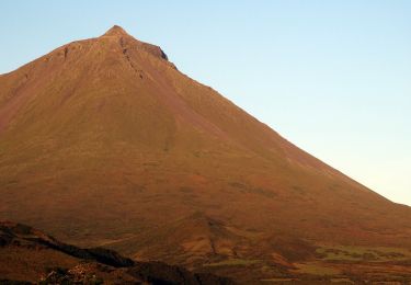
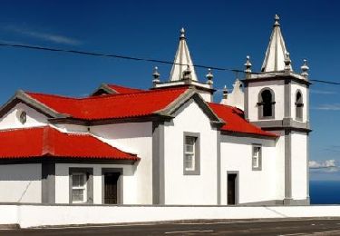
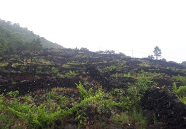
Tocht Te voet van 22 km beschikbaar op Azoren, Onbekend, São Roque do Pico. Deze tocht wordt voorgesteld door SityTrail - itinéraires balisés pédestres.
Beschrijving
Discover the hiking route PR7PIC Caminho das Voltas. View the map and download the GPS track.
Website: http://trails.visitazores.com/en/trails-azores/pico/caminho-das-lagoas
Plaatsbepaling
Land:
Portugal
Regio :
Azoren
Departement/Provincie :
Onbekend
Gemeente :
São Roque do Pico
Locatie:
Unknown
Vertrek:(Dec)
Vertrek:(UTM)
386596 ; 4258940 (26S) N.
Opmerkingen
Wandeltochten in de omgeving
![Tocht Te voet São Roque do Pico - Lagoa do Capitão - Photo](https://media.geolcdn.com/t/375/260/75e970a1-be1c-448e-8612-b96d8c22d45a.jpeg&format=jpg&maxdim=2)
![Te voet Te voet](https://static1.geolcdn.com/sitytour/trail-icons/100.png)
Lagoa do Capitão
Te voet
Gemakkelijk
São Roque do Pico,
Azoren,
Onbekend,
Portugal
![](/images/other/stat-length.png)
4,7 km | 6,7 km-effort
1h 31min
![](https://static1.geolcdn.com/siteimages/upload/files/16400158638029165_repeat_loop_refresh_sync_direction_icon.png)
Neen
![Tocht Te voet São Roque do Pico - Ladeira dos Moinhos - Photo](https://media.geolcdn.com/t/375/260/c17d26ac-7286-4e92-a0ed-d5f1244b852a.jpeg&format=jpg&maxdim=2)
![Te voet Te voet](https://static1.geolcdn.com/sitytour/trail-icons/100.png)
Ladeira dos Moinhos
Te voet
Gemakkelijk
São Roque do Pico,
Azoren,
Onbekend,
Portugal
![](/images/other/stat-length.png)
3,3 km | 5,4 km-effort
1h 13min
![](https://static1.geolcdn.com/siteimages/upload/files/16400158638029165_repeat_loop_refresh_sync_direction_icon.png)
Ja
![Tocht Stappen Prainha - 20230616acores - Photo](https://media.geolcdn.com/t/375/260/13759341-6960-424a-a35b-1033e75a9d90.jpg&format=jpg&maxdim=2)
![Stappen Stappen](https://static1.geolcdn.com/sitytour/trail-icons/101.png)
20230616acores
Stappen
Medium
Prainha,
Azoren,
Onbekend,
Portugal
![](/images/other/stat-length.png)
9,8 km | 13,8 km-effort
4h 16min
![](https://static1.geolcdn.com/siteimages/upload/files/16400158638029165_repeat_loop_refresh_sync_direction_icon.png)
Neen
![Tocht sport São Roque do Pico - Plaia de Baia - Photo](https://media.geolcdn.com/t/375/260/ext.jpg?maxdim=2&url=https%3A%2F%2Fsecurestorage.geolives.com%2Fsitytour%2Ftrail-bg%2Fdefault.jpg)
Plaia de Baia
sport
Heel gemakkelijk
São Roque do Pico,
Azoren,
Onbekend,
Portugal
![](/images/other/stat-length.png)
12,3 km | 17,9 km-effort
Onbekend
![](https://static1.geolcdn.com/siteimages/upload/files/16400158638029165_repeat_loop_refresh_sync_direction_icon.png)
Neen